Pages

Saturday, March 5, 2011

New Zealand - Tongariro Alpine Crossing

After one night in Wellington, we made our way to Tongariro National Park. This was the place where we were going to do our biggest hike yet, the Tongariro Alpine Crossing. It's a 19.4km hike that takes you up and over a volcano range and then down into the beautiful valley that overlooks Lake Taupo. We were especially excited for it because the mountain we'd be hiking past was Mt. Ngauruhoe...also known to Lord of the Rings fans as Mt. Doom!! The morning of our hike, we woke up really early, as we were catching a 5:45am shuttle from our hostel to the beginning of the walk. Since the walk is one way, you have to arrange shuttle transport to get you to the start and then pick you up again.

The walk started out with a fairly flat bit until Soda Spring, when it started to climb steeply. It was a quite hard walk at times. We made it to Red Crater (half way point) at 9:00am. We took lots of picture of Mt. Doom, the Red Crater, and the Emerald Lakes and then made our way down towards Blue Lake. We stopped on a rock to eat our sandwiches and have a bit of a break and then continued on. The last half of the walk was mostly downhill, which was nice at first, but started to hurt our legs and knees towards the end! We had amazing views of Lake Taupo as we made our way into the valley. We hiked pretty hard the last part so we could make the 12:30pm shuttle back to the hostel. The last few kilometers seemed to go on forever! But, we made it back in time for the 12:30pm shuttle!!

Once we made it back to the hostel, we had some well deserved showers and a really long nap. Then woke up to make some dinner and fall back asleep afterwards! It was an amazing, but difficult hike, and we were hurting for a couple days after!


Fun in the sun, followed by pain and dizziness

Chris here,

After we made our 'that's not a knife, THIS, THIS is a KNIFE' knives, we headed up to the Nelsen region of New Zealand. This is in the middle of the northernmost part of the south island, is smack dab in the middle of wine country, and is right beside the beautiful Abel Tasman National Park. Now, you should know that basically the entire south island is a National Park and that it's pretty much all beautiful, but still, it should be mentioned. We were pretty busy over the past few days, so we decided to have a lazy day in Nelsen and then maybe kayak the Abel Tasman coast the next day. We stayed at this sweet as hostel called The Bug, which is definitely one of the best hostels in the country, run by a cool, laid back guy and his family. It's called the bug because everything is VW Beetle themed. Our room was the Lady Bug. Lazy day began with yummy breakfast and a walk up to the 'peak' of Nelsen, where you can see over the entire town. Another great day in NZ, temperatures around 30 degrees and not a cloud in the sky. We sat down and looked over the city, but actually preferred to turn around and look back over the rolling hills and countryside.

Kayaking was probably going to be too time intensive and rushed, so we decided to walk the coastline instead. We took a water taxi from Marahau up to Anchorage Bay, where we saw the famous 'split apple rock' and several amazing beaches. On our walk back we promised ourselves we would hit up a couple of them. Anchorage Bay was great, but better beaches beckoned us, so we hiked up the hills and were on our way. Another 30 degree day, which is kinda too hot to be walking uphill in, so we plunked ourselves down on this little beach and lazed in the sun and swam in the calm bay. It's definitely nice to not have to worry about sharks, jellyfish, or rip tides like you do in Australia. But what you do have to worry about is rocks. Andrea smashed her foot up good on one and she was bleeding everywhere. Good thing we weren't in Australia or there surely would have been several Great Whites swimming right for us. lol.

When we got her back to the beach and bandaged up, it was obvious she was cut pretty bad, but we still had 2 hours to hike, and since Andrea's a trooper and an Army Ranger all in one, she laced up those Keen brand hikers like the keener she is and we marched on out of there. Great scenery, great walk, but the cut on Andrea's foot is not a highlight.

From there we drove to Picton for the night, where we'd catch the ferry the next morning to go to Wellington, but our GPS now has an apetite for the craziest and most off-the-beaten-track paths you can imagine. So many twists and turns up and down hills and mountains that I never had the car straight for longer than half a second the entire trip. Very beautiful (thanks, GPS) but after a long day I just wanted to GET THERE ALREADY! We'll have to keen an eye on that thing...

Saturday, February 12, 2011

New Zealand - Knifemaking


We had read in our Lonely Planet about this couple near Greymouth that teach a one day course where you make your own knife. We thought that this would be a fun and different way to spend a Saturday, so we made our way from Franz Josef to Barrytown for our day of knifemaking. Steven and Robin were a lovely couple and made the day a whole lot of fun. At the end of the day, when we were done our knifemaking, they served us champagne and treated all of us like good friends. It was a really awesome experience!
Forging the steel for our blade

It doesn't look like much, but it's on the way to being a knife!

Blade with brass hilt and wooden handle

Taking a break!

Axe throwing!

Almost finished. Just need to polish the blade and stain the handle.

Our groups finished products. Chris' is the far left and mine is the 6th from the left. The items above the knives are all we used to make our masterpieces!

New Zealand – Glaciers

We spent two days in Franz Josef so we could explore both the Fox Glacier and Franz Josef Glacier (25km from one another). It's a really neat drive to both locations because it's mostly rainforest and it definitely doesn't feel like you are driving towards a massive glacier. At both sites, you are allowed to walk up really close to the glacier terminal face (~100m away). Both of the glaciers had a huge cave at the face where the glacier meltwater comes out. There are so many warning signs telling you not to go past the yellow rope, but people still do and a couple years ago, two men were killed when the walked into the cave area and a massive chunk of ice fell on them. When we were at the Fox Glacier, a massive chunk of ice came crashing down and it was quite loud and scary. We were good tourists and stayed behind the rope to enjoy the views.

On our last afternoon at Franz Josef, we decided to follow and insider tip from our kayak guide in Milford Sound and head to some hot pools located along the Lower Whanganui River. We didn't have much for directions, but we did our best and sort of ended up in the right place, but really lucked out when some local guys came down the track and told us where they were. It was so neat beacuse you would dig into the sand/rocks and hot water would fill the hole. We had to make a connection so we could add some cold water from the river because that water was REALLY hot! It was a lot of fun and a nice way to relax after a few days of walking. Unfortunately, the sandflies really enjoyed the hot pools too and we were eaten alive, but we still had a good time!
Peter's Pool at Franz Josef Glacier

Franz Josef Glacier

Lake Wombat - Franz Josef

Fox Glacier

Hot Pools!

New Zealand – Haast Pass


After we spent the morning throwing Chris out of a plane, we decided to spent the afternoon a little more low key. We drove north from Wanaka to Haast Pass where we decided to do some tramping. Again, the drive was stunning, and we had a lovely time exploring the area around Wanaka. I would say it's probably one of the nicest places on the South Island. We were pretty beat after an adrenaline fueled morning and then an afternoon walking up hills and through rainforest, but it was well worth it!
Lake Hawea (north of Wanaka)

Haast Pass

Lake Wanaka

Skydiving

Part two of making gravity my own personal lap dog was ski diving. I was set up and ready to go at 9:30am, and I wanted the biggest jump, the 15,000ft monster. It's a tandem skydive, so you have a partner who knows what the hell they are doing strapped to you, so you're just along for the ride. These guys do about 15 jumps a day and average about 6,000 jumps each for experience. Are you comforted? I was...a bit.

So we drove over to the airfield and waited, and waited, and waited, as we saw dozens of other people jumping ahead of me. My time was pushed back because the bad weather from the past few days meant that these people got higher priority than me for jumping. While this irked me pretty severely, it's fair, in a way, but by 1pm the wind was just too gusty and they canceled the remaining jumps, which meant I was left high and dry. Not feeling particularly happy about how I was treated, we got the full refund and decided to try again in nearby Wanaka (where we were staying for 2 days), which is very much like Queenstown for scenery but is much less touristy and actually much nicer.

I woke up the next morning and the weather was absolutely amazing. Clear, blue skies as far as you can see. We drove to the airfield, and we (me and the other people jumping) were quickly whisked into the training booth, dressed up, introduced to our jump partners and cameraman and before you knew it we were being seated backwards into a tiny orange plane. I had completely forgotten to ask the guys what colour my shoot was so Andrea could find me in the sky, but she is very observant and knew what colours my jump partner was wearing, so she picked me out very easily. Up and up we went, flying over the valley between Lake Wanaka and Lake Hawea, and the sights were incredible. The flight alone was worth the price of admission. I looked out and saw we were about at mountain level and asked my flight partner how high we were. Only 5,000 feet? Yikes. So we climbed and climbed, making a giant circle over and over again in the sky, and my partner put my oxygen mask over my face (for the altitude, you see) and I looked back down and all of those massive mountains now looked very tiny, almost indistinguishable from the valley floor. He cinched up the harness so were basically one person, and we manoevered to the edge of the door and I dangled my feet out of the plane, bent backwards onto the fuselage. The cameraman, who is, by definition, insane, hangs on the edge with his hands and takes pictures with his teeth. I thought I was pretty badass for skydiving. This guy has badass listed under personal attributes, work experience, education and hobbies on his resume. He gives the thumbs up, I tilt my head back and yell, “Let's go!” and we are launched out of the plane, falling towards the Earth. The feeling is very much like bungeeing and I yelled, in a very manly way, as you can remember from my bungee experience, and we quickly accelerate to terminal velocity, 200kph. The wind was fierce, the air was cold, and thin, the rush was massive, and I was having the time of my life. 60 seconds of freefall just doesn't seem like long enough, even though I'm gasping for air, my mouth dry from the wind and from smiling, and then we release the shoot and we are caught by the wind. I'm disappointed at first, but the feeling of floating to the ground from 4,000ft in a parachute, after falling from 15,000ft at 200kph is like being held in your mother's arms. This great ride last for about five more minutes, and then you fall very peacefully to the ground. I was released from the shoot, gave Andrea the thumbs up, and then got on my knees and kissed the ground. Twice. I stumbled, wobbly kneed over to Andrea, as the oxygen deprivation was finally hitting me, and I was very happy. The rush was incredible, the setting was unbeatable, and the experience was unforgettable. But I think we're doing with the gravity extreme sports, and I'll be keeping my feet on the ground for the foreseeable future.
Getting suited up

Walking to the plane - amazing scenery

Falling from 15 000ft
Great views!


Arriving safely back on the ground

Adrenaline - Bungee Jumping


Extreme sports and New Zealand seem to go hand in hand, and almost from the moment you land in this crazy country, you are reminded that Kiwis rule the extreme and invented bungee jumping after spotting a local tribe that climbed to the top of a high tower with a rope made from a sinewy tree tied to their legs and seeing them jump towards the Earth, which supposedly brought good harvests if your head nearly touched the ground.

So, naturally, I decided to somewhat conquer my fear of heights by bungee jumping at the original site started by AJ Hackett in Queenstown, followed up by a sky dive from 15,000ft (16,400 ft above sea level). I'm not quite sure when it became possible for me to see myself doing these things, but I guess I've killed enough of the right kind of neurons. The day I told Andrea I booked the bungee jump and sky dive was probably one of the most uncomfortable of her life, as she had to stew in apprehension at the thought of my repeatedly plunging toward the ground and doing so willingly. As we got the to bungee bridge, I still wasn't that nervous, as there were a few people lined up ahead of me to go. Sure enough, one by one they were strapped in and jumped and screamed as the bounced around on the cord. I still wasn't worried, but then it was my turn to go. Andrea, I learned later, was becoming increasingly worried about my safety and the tension was starting to get unbearable. As they strapped me into the harness they asked me the typical questions: Where are you from? First time bungeeing? When I answered, “Yes, this is my first time jumping,” the bungee master shook his head and said, “You crazy bastard.”

So the hooked up the cord and told me to jump like I was falling into bed after a long days work. Now the fear was starting to creep up. “Come to the edge and put your toes over,” the bungee master said. It really felt like I was going to walk the plank. I looked over the edge. Okay, scary times. This was the split second in which I thought, “I gotta get outta here,” and, “I think I've made big mistake!” But it's also way too late to turn back now, so it's time to soldier up, big boy! Gotta pump myself up! But before I had time to truly think over how stupid I am, I was told to smile for the camera. Hey, I can do that. Then I was told to wave to Andrea. I did. Hey, Andrea, how's your day going? Then, “Okay, jump on three. One, two, three!” and without really thinking I just jumped like a madman and I was looking straight at the ground, right into the raging river. “AAAAAAAHHHHHHH!” I screamed, though later I was told it was a very manly scream, one that would scare one's enemies, frighten off bears, save villages, et cetera. I'll tell ya what, that ground comes up at you fast, but before you know it you are saved by the harness and you are very, very thankful. Then up into the air, then down, then up, as you bounce around on the cord. They had to hoist me back up to the bridge by hand because of the river was too fast below. Andrea was sure they would drop me, but as soon as I got back to the platform I had my death grip on that bar and I wasn't falling back down there for anything. I was unhooked and released and found Andrea, who joined me on the bridge, in excited and scared tears, and she told me she never wanted to see me do that again. See me. It's fine if I do it, but seeing it is too much. I can imagine. It really is super safe and it's over too fast. The fall was 43m, and they do offer the highest bungee in Australasia at 134m, which is something like 440ft...but maybe I'll do that next time I'm down in New Zealand and feeling crazy...Next up, skydiving!
The Bungee Bridge

Chris jumping!

After the jump - all smiles

I didn't even jump, but the stress was too much for me to handle!

Monday, February 7, 2011

Catching Up

Hello Dear Friends and Family,

Sorry it has been so long since we have written, but we have been having so much fun in New Zealand that we haven't taken anytime to update you on our adventures. We are absolutely loving it here! We've already been gone 12 days, and I wish we could slow down the clock. There is so much to see and do and so many pictures to take!

We have posted 7 blogs about our travels so far. I would have loved to post more pictures, but unfortunately it takes up too much bandwidth to post more.

The first blog is at the very bottom titled: New Zealand - Christchurch. If you work your way up from there, you'll get to our most recent adventure in Milford Sound.

I hope that you enjoy reading about our travels!

Much love,
Andrea & Chris

New Zealand - Milford Sound


Milford Sound is one of those place you have to visit. I could sit here and write all day about how stunningly beautiful it is, how peaceful and quiet it is, but you just have to see it for yourself. I will try to do my best to describe it here.

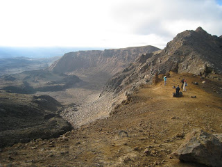
After our one night at Te Anau, we made our way along the highway to Milford Sound. It's only 120km between Te Anau and Milford, but it's a windy road that takes you into the mountains, so it takes a bit of time to drive it. That, and it's a beautiful drive, so we were always stopping along the way to take pictures! The highway from Te Anau is the only way to get to Milford Sound, and once you reach Milford, you're at the end of the road. The only way out is to turn around and drive back to Te Anau. Knowing this, we left Te Anau fairly early so we could beat 'traffic' and get there with plenty of time to explore. We planned on staying 3 nights at Milford Sound so we could do some hiking and kayaking. I wouldn't even call Milford Sound a town. The only things there are: Milford Lodge (which is basically a lodge like backpackers), The Blue Duck (a cafe/pub) and the cruise terminal for the boats that take you on a cruise around the sound. That's it. No souvenir shops, no internet cafe, no grocery store, no gas station. Nothing. I think we were both a bit surprised at this, but I think it's what makes Milford so amazing. There is nothing there. Most people just come from Te Anau for a day trip, but we had wanted lots of time to explore, so I'm glad we stayed at the lodge. By the time we arrived, it was pouring rain outside, and with nothing else to do, we pulled out the crib boad and the Uno cards, bought a bottle of wine from the reception desk, and occupied ourselves for the rest of the day. We had a busy day planned for the next day, so it was kind of nice having an afternoon sitting inside, looking out at the rain and the mountains, drinking some wine, and playing some games.

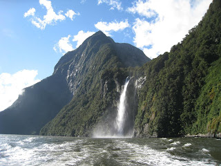
The next morning we woke up bright and early because we had a kayaking adventure waiting for us!! We had booked a 5 hour kayak tour of the sound for the morning, and in the afternoon we had booked a 2 hour cruise of the sound. The kayak tour was amazing, but so tiring. It was good to do it in the morning because the water was quite calm to start and only got a bit rougher near the end of our tour. We were picked up from the lodge at 8am and then driven 5 minutes down the road to where the kayak company (Rosco's) was. We were provided with thermals, a fleece, raincoat, spray skirt and lifejacket. We were in double kayaks, so Chris was in the back steering and I was up front trying to direct us! It was just us, another couple, a young guy and the guide, so it was a great group. We kayaked around the sound where we saw Sterling Falls from quite a distance (9km away), The Lion (a mountain), Mitre Peak, Bowen Falls, and Deep Water Basin. Halfway through our kayak, the sun started shining, the cloud lifted and it was absolutely beautiful! We got to get up really close to Bowen Falls (160m high waterfall) and Chris and I got stuck on the rocks and bit and I started to panic, but of course Chris stayed nice and calm and got us turned around onto the right track. The kayak trip was a full 5 hours, and we were both exhausted by the time we finished. We were driven back to the lodge where I climbed right into bed because I was wiped! Chris made himself some lunch and then had a nap too. We woke up around 2:30 and chilled out for a bit before it was time to get ready for our cruise of the sound at 4:00pm. We were booked for a two hour cruise with Mitre Peaks, a smaller cruise company. We were really lucky because the sun was shining and there weren't too many clouds blocking the peaks. Also, there were only 18 people on the boat, so we had great views. The cruise was lovely, taking us all around the sound and into the Tasman Sea. We got up close to Sterling Falls, saw lots of fur seals, and had amazing views of the mountains! We took lots and lots of pictures!! Once we finished our cruise, we went back to the lodge where we made some pasta/grilled cheese and then turned in for the night. It was a pretty tiring day!

The next morning we woke up with grand intentions of doing a 3-4 hour hike before doing another 5 hour kayak/hiking tour. But, when the alarm went off at 6am, neither of us was in the mood to go tramping, so we decided to sleep in and spend the morning planning some more adventures for New Zealand and Australia. At 2pm, we were picked up by Rosco's so that we could kayak Deepwater Basin towards Sandfly Point and the end of the Milford Track where we'd do a 3km return walk to Lake Ada, and come back to our kayaks and paddle back to Deepwater Basin. Unlike yesterday, which was sunny and warm, our afternoon started off overcast with a light drizzle. But that was okay with us because we were hoping to see some great waterfalls. There was only 4 of us, plus the guide and his friend, so another small group, which was great. The water was so calm and peaceful, so it was a great day for kayaking. We paddled around Deepwater Basin and saw about 4 or 5 young male sea lions playing in the water. We were so close to them, it was amazing! We kayaked to the end of the Milford Track, which is where we started our 1.5 hour walk to Lake Ada. It was a really lovely walk through some wonderful rainforest. The rain was starting to come down quite heavy at this point, but we had good rain gear on, so weren't bothered by it. Our guide Luke was very knowledgeable about the native plants and showed us a bunch of neat ones along the way. We arrived at Lake Ada, but the sandflies were out in full force, so we didn't stay too long before heading back to the kayaks. By the time we reached the kayaks it was pouring down with rain, but still the water was nice and calm. Plus, with all the rain coming down, we were able to see some amazing waterfalls that only appear when it rains. We had a good paddle back to the launch area and then were driven back to the lodge. It was nice to get out of our wet clothes!!!

Milford Sound was definitely a highlight of our New Zealand adventure. It's such a beautiful, peaceful place. Unfortunately, we didn't get to do as much hiking as we would have liked, but I guess that will just give us a reason to return to Milford Sound one day!

P.S. It rains A LOT in Milford Sound. It rains 8m (yes, 8m) a year and 200 days a year. So, each day that it rains, that's an average of 40cm in a day. CRAZY!
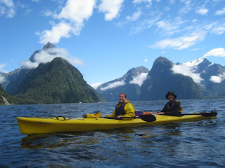
Kayaking Day 1


Sterling Falls - 150m high

Bowen Falls - 160m

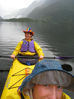
Kayaking Day 2 - Gotta love Chris' water-proof hat. Stylish and functional!

New Zealand - Te Anau

After 3 days in Invercargill, we made our way to Te Anau for one night before we headed to Milford Sound. Te Anau is a beautiful little town that sits beside a lake of the same name. It didn't take us long to drive there from Invercargill, so we were in good time to do a hike along Lake Te Anau. Te Anau is the starting point of two big hikes: the Kepler Track and Milford Track. Kepler Track is a 60km circular track that starts at Te Anau and goes into the Kepler Mountains. It's a 4 day hike with huts to stay at along the way. The Milford Track is one of the most famous in the world and is a 53.5 km hike that starts at Te Anau and ends at Milford Sound. Since it's such a popular route, you have to follow a one-way, 4 day itinerary.

Our little walk that we did was the first bit of the Kepler Track. We walked from the starting point at the end of the Lake to Brod Bay (5.5km) and then back. It was an easy hike along the edge of the lake, but kept you in the rainforest for most of the way which keeps you sheltered from the sun. If you were to continue on from Brod Bay, the hike starts to make a steep ascent into the mountains. We weren't that adventurous, so we ate our lunch along the lake at Brod Bay and then headed back to the start of the track. Once we were done, we headed into town so we could book some activities for Milford Sound at the i-site. After that it was a beer on the patio of The Moose pub before we headed to our hostel for some supper. We met a nice Czech couple at the hostel who were starting the Kepler Track the next day. The husband was all excited, but the wife didn't seem too gung-ho about the idea of hiking for 4 days. I hope they had a good time.
Beginning of Kepler Track - to Brod Bay

Brod Bay

The drive to Te Anau

New Zealand - The Catlins


We stayed in Invercargill for 3 nights so that we could explore The Catlins, a regions between Invercargill and Dunedin filled with lush farmland, forests, and beautiful ocean bays. There are numerous walks and sights to see all along the highway, so we decided we'd drive east to Nugget Point and then make our way back towards Invercargill, making sure to stop to do our hikes and walks along the way. The drive is quite beautiful, but very windy and hilly, so it took us awhile. We stopped to stretch our legs at McLean Falls and did a 30 minute return walk to see the falls. It was a nice walk and the falls were quite lovely, though the water was sort of brownish.

After that, we stopped to visit Tunnel Walk, a short walk that took you to this old railway tunnel that was built by hand in the 1870s. It was so dark inside, and we didn't have a flashlight, so it was a bit difficult to see, but still quite impressive. It's hard to believe that people tunneled through rock with nothing but picks and wheelbarrows.

After Tunnel Walk, we made our way to Owaka to get some info from the i-site on the best way to get to Nugget Point. The wind and rain were so intense that we ate our lunch in the car parked on the road by the i-site. It was still lovely! After lunch we made our way to Nugget Point, the farthest east that we wanted to go, in order to see the lighthouse and the cliffs. It was incredibly windy!!! But, the sun was shining for a bit, so that was good. It was a 1km walk from the car park to the lighthouse along a path that was right on the edge of the cliff, so we made sure to pay attention to where our feet were going! We were able to snap some great pics before we made our way back to the car. As soon as we got in, it started to pour, which seemed to be how the rest of the day would go. It would rain while we were driving and clear up just as we were doing our walks. The wind would howl the entire time.

After Nugget Point, we made our way to Purakaunui Falls where I really wanted to take some photos of the water cascading over the rocks. We were really lucky on all of our walks because no one else was around when we would show up. Same with Purakaunui. We were able to set up the tripod and get some great photos.

We then headed to Jack's Blowhole. A massive hole in the ground, 200m inland from the ocean, where water enters in through a cave...kind of hard to describe. The hole was 144m long, 68m wide, 55m deep, so it was quite impressive! There was a little platform you could stand on and see down into the hole and where the water entered from the ocean. The walk to and from the blowhole was stunning. You walked through farmland where sheep were grazing and you had amazing views of the ocean!

After the blowhole, we headed to Matai Falls and Horseshoe Falls, a 30 minute walk where you could see the lovely falls. By this time, we were quite tired, so the walk seemed a lot harder than it actually was!

We weren't quite done our day just yet! We wanted to see the Cathedral Caves, but since you could only go at low tide, we had to wait until the very end of the day. Low tide was at 7:40pm, and you had one hour on either side of that to see the caves. We got to the car park around 6:00pm and decided to just sit for a bit and rest before we headed down. It was raining and windy, so it was nice to sit in the car and have shelter. Around 6:30pm, we paid our $5 each and made our way down towards the beach to see the caves. It was a downhill walk from the car park through the forest before you got to the beach, then it was another 10 minutes of walking until you reached the caves. It was well worth it though!! The caves were amazing. There were two of them side by side, connected to each other by a passage at the backs of the caves. They were so high and very dark in the back! The water was coming into the start of the second cave (the opening was closer to the water than the first cave), so there were a few times where we had to jump on some rocks to keep dry! We really enjoyed the caves and they were well worth the wait! The walk back up to the car park was exhausting though!! We didn't make it back to Invercargill until after 9pm. We made a quick dinner and then played some card games before it was time for bed. Another wonderful, but tiring day!
Nugget Point

Purakaunui Falls

Cathedral Caves

Cathedral Caves

The walk to Jack's Blowhole

New Zealand - Moeraki Boulders

30km south of Oamaru you'll find the Moeraki boulders (Te Kaihinaki). Scattered along a stretch of beach, these perfectly spherical boulders look completely out of place on an otherwise empty beach. I'm not too sure of the history behind these massive boulders, but they sure were neat to see. Some of them have split open, so there are chunks of broken boulders along the sand. It was an interesting site to see.


New Zealand - Mount Cook


After three great days in Christchurch area, we woke up super early so we could drive to Mount Cook and do some hikes there before heading to Oamaru for a night. It was a 4.5 hour drive from Christchurch to Mount Cook and then another 2 hours from Mount Cook to Oamaru. We knew we had a busy day ahead of us, but were really excited to explore Mt Cook, the highest mountain in Australasia at 3000m. The drive to Mt. Cook was beautiful (like all our drives so far!). We stopped at the i-site (information kiosk) at Mt.. Cook to buy a $1 guide for all of the walks to do on the mountain. We decided to do the 3-4hr Hooker Valley walk that takes you over 2 swing bridges that cross the Hooker River to get to the base of Mt. Cook and where the Hooker River begins. It was an amazing, but challenging walk as a lot of it was over large rocks and boulders. After the second swing bridge, we stopped on some rocks to have our sandwiches and take some photos. We were going to turn around just over halfway through because it got very overcast and rainy and we didn't think we'd see the mountain, but we decided to finish the walk...we didn't come all this way to quit! And we were rewarded with amazing views at the end!! The weather cleared up and the sun came out, so by the time we reached the end of the hike, at the base of the glacier/mountain, we were able to see the entire 3000m of mountain! It was amazing! We stopped and had some apple for snack and sat and enjoyed the view. Chris stuck his hand in the glacier water, but pulled it out pretty quick!

We walked quite briskly on the way back because we wanted to do another walk to the Tasman Glacier. By the time we were done the Hooker Valley walk, we were tired, but wanted to keep going. So, we got in the car and drove to the car park where we could do the Tasman Lake/Glacier walk. It was only a 50 minute walk, but after walking all morning, we were quite tired! The walk was through a boulder field, so not quite as picturesque as the walk to Mt. Cook, but still enjoyable. The lake was massive and had iceburgs from the glacier floating in it. We sat and enjoyed the view for a bit before we headed back to the car park. Once there, we got ourselves organized and ready for the drive to Oamaru.

The drive to Oamaru was really nice and not too long (~2hrs). We arrived in the town at about 7pm and pulled up to our hostel (Empire Backpackers) which was in a really neat building which was constructed in the 1870s. It was a small place, but lovely and nice and quiet! Once we were settled, we made some dinner and then relaxed for a bit. At 9:30pm, we walked down to the ocean to see the penguins come in for the night, but we only saw one little guy sitting on the rocks, and it was getting pretty dark, so we headed back to the hostel. It was an absolutely amazing day, but we were exhausted by the end.
The start of our hike. Hooker River and the first swing bridge.

The cloud started to lift and you could see a bit of Mt. Cook

We made it! And the sun came out and the cloud started to go away!

The beautiful Mount Cook